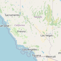
- Map Distribution
- Description
- eFlora Distribution
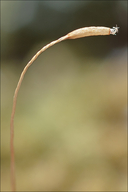
- Illustrations
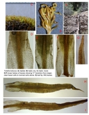
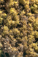
- Cal Photos images
- Elevation by latitude plot
MAP CONTROLS
1. You can change the display of the base map and layers by clicking on the layer control box in the upper right-hand corner.
2. California county polygons can be turned off and on in the layer control box.
3. Filling of Jepson subdivision polygons can be turned off and on in the layer control box.
Database links
UC Specimens in the University and Jepson Herbaria Public Portal
Specimens of Tortella tortuosa in the Consortium of North American Bryophyte Herbaria portal (CNABH)
No Taxonomic Notes.
No Description.
Vouchers: Alpine Co.: Noble Canyon Trail near junction with Pacific Crest Trail, Toiyabe National Forest, Norris 99691; Fresno Co.: canyon above Boyden Cave, Monarch Wilderness, Sequoia National Forest, Shevock & York 13617; Mono Co.: Convict Creek above Convict Lake, Inyo National Forest, Shevock 13792; Shasta Co.: Fall Creek Road about 1 mile southeast of McCloud Bridge at Shasta Lake, Shasta-Trinity National Forest, Norris 84880 and Highway 299 at Oak Run Road, Norris 80315 & 80336; Siskiyou Co.: near Echo Lake north of Red Butte about 5 air miles north of Seiad Valley, Klamath National Forest, Spjut 1057 (UC) and Norris 57607.
Literature: Spjut 1971.
Geographic subdivisions for Tortella tortuosa: CaR, NW, SNE. |
Illustration References: Malcolm et al. 2009 p. 151; Abramov and Volkova 1998; Crum and Anderson 1981; Flowers 1973; Ignatov and Ignatova 2003; Ireland 1982; Lawton 1971; Sharp et al. 1994; Smith 1978; Zander 1993.
No illustrations found in database.
|