Carl Purpus, Plant
Collector in Western America
Carl Purpus, Plant
Collector in Western America By Arnold (Jerry) Tiehm
With additional editing by Barbara Ertter and Tom Schweich
| Carl Purpus, Plant
Collector in Western America | Geographical Index of Carl Purpus -- W |
| By Arnold (Jerry) Tiehm With additional editing by Barbara Ertter and Tom Schweich | |


|
A, B, C,
D, E, F,
G, H, I, | |
|
Query: G.N.I.S. | Wah Wah Springs, Utah. | |
|
"… near Frisco Western Utah." The present day Wah Wah Springs is 1 mile south of Utah Highway 21, approximately 30 miles west of Milford, Utah. The site of Frisco, Utah is approximately 8 miles west of Milford, Utah.
| ||
|
Query: G.N.I.S. See also: Indian Wells
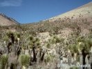
Valley. Isabella. | Walker Pass, Kern County, California. | |
|
Located at the Sierra Nevada Crest, at approximately 5300 feet
elevation along California Highway 178 from Bakersfield to
U. S. Highway 395 in Indian Wells Valley,
T26S, R37E, S17 and 35° 40'N, 118° 2'N.
1896, 1897, 1898.
Articles that refer to this location:
Letters that refer to this location:
| ||
|
Query: G.N.I.S. See also: Bridgeport. | Walker River, Mono County, California. | |
|
Purpus traveled up the East Fork of the Walker River to reach Bridgeport.
1898.
Articles that refer to this location:
| ||
|
Query: G.N.I.S. 

| Walnut Canyon, Coconino County, Arizona. | |
| Ten miles east of Flagstaff, south of Interstate 40. Now Walnut Canyon National Monument. 1902. | ||
|
Query: G.N.I.S. See also: Inyo Mountains.
White Mountains.
Deep Springs Valley. Toll House. | Westgard Pass, California. | |
|
Articles that refer to this location:
| ||
|
Query: G.N.I.S. 
| Whetstone Mountains, Cochise County, Arizona. | |
|
1903. The present day Whetstone mountains are 15 km southwest of Benson, Arizona, and 72 km southeast of Tucson Arizona.
| ||
|
Query: G.N.I.S. | Whiskey Flat, Mineral County, Nevada. | |
|
"Whisky Flat." Bounded by the Wassuk Range to the west and the Garfield Hills to the east. T6N, R31E and 38° 23'N, 118° 33'W. 1898. | ||
|
Query: G.N.I.S. See also: Beaver Dam Mountains. | White Hills, Utah. | |
|
Query: G.N.I.S. See also: Inyo Mountains.
Deep Springs Valley. Fish Lake Valley. Owens Valley. Toll House. Westgard Pass. Excelsior Range. Sand Spring. | White Mountains, Inyo and Mono Counties County, California. | |
|
Large range north of the Inyo Mountains and bounded by Owens and Chalfant
Valleys on the west and Fish Lake Valley on the east.
1898.
Types described from this location: Articles that refer to this location:
Letters that refer to this location: | ||
|
Query: G.N.I.S. 
| White River, Tulare County, California. | |
|
On the west side of the Sierra Nevada having its headwaters
on the west side of Bull Run Peak and flowing through the town of White River.
1897.
Articles that refer to this location: | ||
| Query: G.N.I.S. See also: Hockett Meadows. | Whitman Creek, California. | |
|
Query: G.N.I.S. See also: Golden Trout Creek. | Whitney Creek, Tulare County, California. | |
|
Now called Golden Trout Creek and is located in the Sierra Nevada
with its headwaters above Big Whitney Meadows and joins the Kern River just north
of the Kern Canyon Ranger Station.
1896.
Articles that refer to this location: | ||
| Query: G.N.I.S. | Whitney Meadows, Tulare County, California. | |
| 1895. | ||
|
Query: G.N.I.S. See also: Timpah-ut Range. | Worthington Mountains, Nevada. | |
|
A, B,
C, D, E, F, G, H, I,
J, K, L,
M, [Home Page] Date and time this article was prepared: 6/7/2002 7:34:33 PM | ||