 Carl Purpus, Plant Collector in
Western America
Carl Purpus, Plant Collector in
Western America Barbara Ertter
|
Carl Purpus, Plant Collector in
Western America | On the Trail, with Purpus, in California (Continued) |
| Barbara Ertter |


Topics in this Article: Literature Cited | |
| Other Articles: Purpus' Introductions: 0350
| "A little bit of excitement, often of a rather dangerous nature, is unavoidable on such journeys. The flats and dry foothills of the Sierra teem with rattlesnakes, One must always take care to avoid disturbing one of these dangers, well aware of its lethal weapon, from where it lurks. In the mountains, in addition to the harmless black bear, there is the dangerous grizzly. Encountering one unexpectedly is a distinct adventure. One day as I climbed a slope, I suddenly saw directly above me a large cinnamon bear approaching from one side. I had no weapon with me, so I was of course at first sight startled. I tried to scare the animal away, but without success. The bear held its ground with dreadful rolling eyes, and finally came at me. I was foolish enough to jump at him, whereupon the beast stopped, snarling but not retreating. By now I had become quite uncomfortable with the situation, so I moved slowly backwards, keeping an eye on my furious companion. The animal appeared to pay no further attention to me, and I quietly resumed collecting. Although I still feared an attack at any moment, the beast did not bother me again"
| 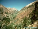 Looking toward Broder Cabin and Farewell Gap, Sierra Nevada, California.
Locations: Farewell Gap. Hockett Meadows. Little Kern River. Maggie Peaks. Middle Tule River. Mount Moses.
Purpus survived his first year in the Sierra Nevada and returned the
following summer. His description his travels in 1896 are somewhat
less effusive, but more descriptive of his actual route. He left
Springville with a guide and several pack animals in June and headed
up the Middle Fork of the Tule River. They were forced to camp until
the middle of June, "... facing the fantastic rock walls of the
Maggie Peaks ...," waiting for the snow in the passes to recede.
He explored Mt. Moses, where he discovered Echeveria purpusii,
according to a letter written to Katharine Brandegee. The camped for
ten days in Hockett Meadows, ascending the surrounding peaks, before
continuing to the headwaters of the Little Kern River. Many of his
collections from this region are from Farewell Gap, between the Kern
and Kaweah drainages.
|
|  Trout Meadows, southern Sierra Nevada, California.
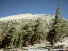 Olancha Peak, Sierra Nevada, California.
Locations: Golden Trout Creek. Lyon Meadows. Monachy Meadows. Olancha Peak. Trout Meadows. Whitney Creek.
After a fortnight they headed down the Little Kern River to Lyon Meadows
and Trout Meadows, where they were caught in a violent hail storm. They
crossed the swollen river and proceeded up Golden Trout Creek, which
Purpus called Whitney Creek. Along with the vegetation he described
the prominent volcanic craters along the stream and the exceptionally
large specimens of Juniperus. Purpus refers to his next major
camp and collecting site as "Monatchy Meadows", but because he describes
Olancha Peak to the southeast he was apparently in Ramshaw
or Strawberry Meadow instead. He climbed Olancha Peak and described his
"... fantastic view overlooking the Owens River Valley with the deep
blue Owens River Lake ..." One of the plants he collected on Olancha
Peak was a Monardella that remained undescribed for over 90 years.
|
| 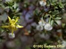 Larrea tridentata.
  Owens Lake from Olancha Peak, California.
Other Articles: Purpus' 1896 Trip: 0180 Locations: Corcoran Peak. Coso Mountains. Cottonwood Creek Canyon. Owens Lake. Owens Valley. Letters: 10/27/1896
Purpus then descended into the Owens River Valley following Cottonwood
Creek Canyon. He collected around the alkali lake and surrounding
desert, including an excursion to the Coso Mountains, where he was
impressed by a magnificent treelike Yucca. He also noted the
fascinating Psorothamnus fremontii, "... low, pleasantly
aromatic shrubs with sharply bent branches ..." and Larrea
tridentata, "... covered with small white-haired fruit ... without
doubt the most interesting in western North America." After several
weeks in the valley, they began their return trip. Enroute Purpus
climbed Corcoran Peak, or "Old Mount Whitney," and collected again
around Farewell Gap and the Little Kern River.
|
| 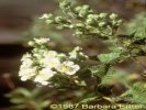 Chamaebatiaria millefolium.
 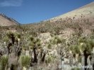 Joshua Tree Woodland near Walker Pass.
 Other Articles: Purpus' 1896 Trip: 0250 Locations: Walker Pass. He returned to
Springville at the beginning of September, but set out
soon after to return to Cottonwood Creek Canyon. To avoid the danger
of snow storms in the high mountains at this late season, he took a
southern route over Walker Pass. His goal was to collect seeds of
Chamaebatiaria millefolium, which he considered one of the
loveliest shrubs in the eastern Sierra Nevada: "A more beautiful
shrub than this magnificent one cannot be imagined." On his return
trip he again explored the Coso Mountains, although most of the annuals
were long past. He arrived back in Springville in late October,
after a journey he said was "... blessed with perfect weather."
|
|
Other Articles: Southern Sierra, Argus and Madurango Ranges (1897): 0010 Locations: Porterville.
In early May of 1897 he and his companion again headed for Walker Pass,
this time with a wagon. Enroute he described "... the small town of
Porterville, distinguished by its lovely orange and citrus groves ..."
and "... an undistinctive hilly area, part treeless, part forested ..."
through which "... occasional watercourses meandered as green
ribbons ...," and "... golden wheatfields awaiting harvest [that]
stretched for miles ...," all of which still characterize the region.
|
| 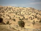 Blue Oak Savannah, near White River, California.
Other Articles: Southern Sierra, Argus and Madurango Ranges (1897): 0020 Locations: Cedar Creek. Deer Creek. Greenhorn Pass. Linns Valley. White River.
After camping at Deer Creek, they passed by White River: "Gold mining
had once been attempted here, but the venture was not very productive".
They camped at a spring in Linns Valley, where " ... hill and dale
were clothed in a glad green ..." From here they followed an
"... excellent, well-shaded trail [that] led rather steeply uphill
to Greenhorn Pass ...," stopping partway up at Cedar Creek,
"... a small, crystal-clear mountain spring ..." One of the shrubs
he notes in this area is a Garrya laden with fruit,
which he says is called "quinine tree", "... because all of
its parts contain a terribly bitter substance."
|
| 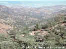 Erskine Creek drainage, Piute Mountains, California.
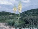 Yucca whipplei.
 Other Articles: Southern Sierra, Argus and Madurango Ranges (1897): 0080 Locations: Erskine Creek. Hot Spring Valley. Isabella Lake. Piute Mtns.
On the eastern side of Greenhorn Pass Purpus was treated to
"... a beautiful view of the green valley where the North and South
Forks of the Kern River meet, bounded by steep, rather bare,
rocky mountains ...," now the site of Isabella Lake. They crossed
the Kern River and headed south to Hot Spring Valley. His goal was
the Piute ("Pah-Ute") Mountains, where he planned to spend a few weeks
botanizing. They proceeded up Erskine Creek, following "... the crystal
clear creek upstream ... to where it flowed out of a narrow glen ...
The glen eventually widened and the slopes were not as steep ...
The chapparal was only on the north slopes of the mountains ...
The south slopes were characterized by sparse shrubbery interspersed
with quantities of Yucca whipplei, a lovely sight with its
huge inflorescence of large bell-like flowers rising above its leaves."
|
|  Forsellesia nevadensis.
Locations: Laura Peak. Purpus camped on L. B. Hobson's
ranch at the foot of what he calls
Piute Peak, which from all indications is probably present-day Lookout
Peak. He also explored Laura Peak, a distinctive limestone peak in a
generally granitic region, where he found an isolated population of
Forsellesia, otherwise unknown from the Sierra Nevada. Among
the new species he discovered in the Piute Mountains was the lovely
Delphinium purpusii Brandeg. In a letter to Katharine Brandegee
dated May 23, he describes "... an other Echeveria, which is alltogether
different from E. purpusii it grows on Granit and limestone rocks
and has smaller leaves and stroh colored flowers ..."; this is the
plant that has recently been described as Dudleya calcicola
Bartel & Shevock. His published travelogue mentions a
Cupresses he did not recognize, an obvious reference to the
endemic Piute Cypress.
|
|
Other Articles: Southern Sierra, Argus and Madurango Ranges (1897): 0180 Locations: Indian Wells.
Purpus left the Piute Mountains mid-June and proceeded through the
valley of the South Fork of the Kern River to Walker Pass. He describes
the stand of Joshua tree that span the pass, which "... presented
a very interesting, remarkable sight, and gave the landscape a
southern character ..." After camping at a willow-shaded spring on
the east slope, they headed to Indian Wells. He writes:
|
|
Other Articles: Southern Sierra, Argus and Madurango Ranges (1897): 0200 Locations: El Paso Range.
| To the left rose the wonderfully sculptured peaks of the Sierra, bare of sparsely forested with Pinus monophylla. To the right were the dark, volcanic ridges of the El Paso Range, and to the northeast, the bare peaks of the Argus Mountains and part of the Coso Mountains. Between the reddish gray mountains rose a dark red to black extinct crater, very characteristic of these mountains. The places where lava had flowed down the mountain slopes and poured forth onto the plains were very interesting. It looked as if such areas were shaded by clouds while the lighter parts of the mountains were in the full glare of the sun.
|  Argus Peak from the west.
 Other Articles: Southern Sierra, Argus and Madurango Ranges (1897): 0220 Locations: Argus Peak. Argus Range. Maturango Peak. Mountain Springs Canyon. Panamint Mountains. Salt Wells. Letters: 12/19/1896
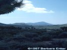
From Indian Wells they crossed the desert to the east, arriving that evening, tired and thirsty, at Salt Wells. The next morning they continued north to the Argus Range: "... Although the mountains appeared to be close to us, it took eight hours to reach them ..." Purpus explored the Argus Range until the end of June, based first at the mouth of Mountain Spring Canyon and then at the foot of Argus Peak. He also visited Maturango Peak, admiring the view east to the Panamint Mountains. According to Purpus, the Argus Range derives its name from the numerous scattered shrubs, which give the range the appearance of having a hundred eyes.
|
| On his return trip,
Purpus backtracked to the Piute Mountains, where
he collected for two more weeks. He then returned to Springville for
a month-long recuperation, after which he collected around the
headwaters of the Kaweah, Little Kern, and Middle Tule rivers until
late September. In a letter to Katharine Brandegee [8 September 1897]
sent from Broder's Cabin in Mineral King, he writes:
|
| Letters: 9/8/1897 | I had a very bad experience with Capt. Gale who is superintendent of the Park, as he was about ready to turn me and my man, who helps me collecting out of the park, although I had a letter of introduction to him by the General from last year.
| It sounds as if
Captain Gale were more effective in keeping
botanists out of Sequoia Park than sheep, based on a letter from
the previous year [19 December 1896]:
|
| 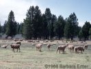 Sheep near Stampede Reservoir, California.
Letters: 12/19/1896 | It is of no use to go a third time into these Mountains, because I think I have collected almost everything worth collecting and because the feed in that big sheep pasture - the Sequoia park not included - is getting so scarce, that it is quite impossible to stay in one place for more than three or four days. It was worse this summer, than I ever have seen it before and I would not have been surprised to see some of those Basks with their flocks on the very top of Mt. Whitney; They pretty near reached the top of Old Mt. Whitney though, and when they had cleanded [sic] out every grass spot in the so called reservation - that name is nothing but a mockery, the[y] went into the Sequoia park allthough protected by soldiers of the U. St. Army. |
[Previous Page] [Next Page] | |
| [Published Biographies] [Travelogues and Articles] [Letters] [Plant Lists and Bibliography] [Site Administration] | | Date and time this article was prepared: 6/7/2002 7:32:38 PM |