- Map Distribution
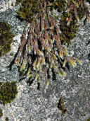
- Description
- eFlora Distribution
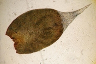
- Illustrations
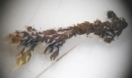
- Cal Photos images
- Elevation by latitude plot
MAP CONTROLS
1. You can change the display of the base map and layers by clicking on the layer control box in the upper right-hand corner.
2. California county polygons can be turned off and on in the layer control box.
3. Filling of Jepson subdivision polygons can be turned off and on in the layer control box.
Database links
UC Specimens in the University and Jepson Herbaria Public Portal
Specimens of Hedwigia stellata in the Consortium of North American Bryophyte Herbaria portal (CNABH)
No Taxonomic Notes.
No Description.
Vouchers: Contra Costa Co.: Castle Rocks, Mt. Diablo State Park, Shevock & Ertter 20354 ; El Dorado Co.: Sopiago Creek southeast of Placerville, Eldorado National Forest, Norris 67187; Humboldt Co.: Bald Hills Road at Coyote Peak, Norris 22333; Lake Co.: Mt. Konocti just below Buckingham Bluffs, Shevock, Heise, Harpel, & Toren 20598; Los Angeles Co.: Santa Anita Canyon, San Gabriel Mountains, Angeles National Forest, Moxley 994 (MO); Monterey Co.: Arroyo Seco Road near Carmel River, Toren & Showers 2883 (SFSU); Riverside Co.: Cahuilla Mountain above Tripps Flat, Shevock 20532; Santa Cruz Co.: Eagle Rock, Kellman 1272 (CAS); Shasta Co.: Fall Creek Road, 1 mile southeast of McCloud Bridge, Shasta Lake, Norris 84860.
Literature: Buck and Norris 1996; Kellman 2003. [See notes for Hedwigia detonsa.]
Geographic subdivisions for Hedwigia stellata: CaR, CW, NW, SN, SW. |
Illustration References: Buck and Norris 1996.
No illustrations found in database.
|