- Map Distribution
- Description
- eFlora Distribution
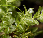
- Illustrations
- Cal Photos images
- Elevation by latitude plot
MAP CONTROLS
1. You can change the display of the base map and layers by clicking on the layer control box in the upper right-hand corner.
2. California county polygons can be turned off and on in the layer control box.
3. Filling of Jepson subdivision polygons can be turned off and on in the layer control box.
Database links
UC Specimens in the University and Jepson Herbaria Public Portal
Specimens of Plagiomnium cuspidatum in the Consortium of North American Bryophyte Herbaria portal (CNABH)
No Taxonomic Notes.
No Description.
Vouchers: Placer Co.: Kings Beach near shore of Lake Tahoe, Lake Tahoe Basin Management Unit, Matson 367 (UC); Shasta Co.: Highway 299 about 24 miles east of Redding, Norris 21596; Siskiyou Co.: near Ducks Lake Trail near Parrots Mill Road, Norris 22829; Tulare Co.: Redwood Canyon, Redwood Mountain Grove, Kings Canyon National Park, Dennis s.n. (CAS).
Literature: Kellman 2003. As Mnium cuspidatum Flowers 1973; Koch 1950a; Wyatt and Odrzykaski 1998.
Geographic subdivisions for Plagiomnium cuspidatum: CaR, CW, NW, SN. |
Illustration References: Malcolm et al. 2009 p. 171; Abramov and Volkova 1998; Crum and Anderson 1981; Flowers 1973; Ignatov and Ignatova 2003; Ireland 1982; Lawton 1971; Sharp et al. 1994; Smith 1978.

|