- Map Distribution
- Description
- eFlora Distribution
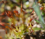
- Illustrations
- Cal Photos images
- Elevation by latitude plot
MAP CONTROLS
1. You can change the display of the base map and layers by clicking on the layer control box in the upper right-hand corner.
2. California county polygons can be turned off and on in the layer control box.
3. Filling of Jepson subdivision polygons can be turned off and on in the layer control box.
Database links
UC Specimens in the University and Jepson Herbaria Public Portal
Specimens of Tortula leucostoma in the Consortium of North American Bryophyte Herbaria portal (CNABH)
No Taxonomic Notes.
No Description.
Vouchers: Modoc Co.: Highway 139 at Biles Road about 13 miles northwest of Canby, Norris 70480; Tehama Co.: Howard Creek trail about 1 mile east of Highway 299, Norris 55496 and Highway 36 east of Red Bluff at Mile Creek, Norris 21243.
Geographic subdivisions for Tortula leucostoma: CaR, MP. |
Illustration References: As Desmatodon leucostoma Lawton 1971.
No illustrations found in database.
|