Field Notes of Annie Alexander and Louise Kellogg Geographical Index of Annie Alexander and Louise Kellogg -- C

By Tom Schweich

Home Page
  • A combined geographical index for Annie Alexander and Louise Kellogg, Carl Purpus, and Tom Schweich is available at Combined Geographical Index -- C.
  • All locations are in the United States, unless another country is explicitly listed in the entry.
  • Locations in the United States may be compared with the United States Geological Service: Geographical Names Information System by clicking on Query: G. N. I. S.


A, B, C, D, E, F, G, H, I,
J, K, L, M, N, O, P, Q, R,
S, T, U, V, W, X, Y, Z


Query: G.N.I.S.
C. C. C. Camp, Clark County, Nevada.

Articles that refer to this location:


Query: G.N.I.S.
Cadiz Dry Lake, San Bernardino County, California.
Large dry lake in the southern Mojave Desert, southeast of Amboy.

Articles that refer to this location:


Query: G.N.I.S.  
Carson Pass, California.
Pass through the Sierra Nevada.    
 
Query: G.N.I.S.

See also: New York Mountains. Fourth of July Canyon. Full Size Image Full Size Image Full Size Image Full Size Image Full Size Image Full Size Image Full Size Image Full Size Image Full Size Image Full Size Image Full Size Image Full Size Image

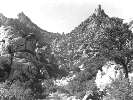
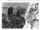
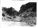
Caruthers Canyon, San Bernardino County, California.
Canyon on the south side of the New York Mountains.

There is some thought that "Caruthers" should be spelled with two r's as "Carruthers." This is apparently noted in book by Ausmus and Casebier. Also, Figure 17 on page 21 of Reynolds and Reynolds (1995) implies that Carruthers may be an alternate spelling of Caruthers. However, Caruthers seems to be the aopted spelling for use on maps, etc.

Articles that refer to this location:

 
Area Plant Lists that contain this location:
 
Query: G.N.I.S.
Casa Diablo Hot Springs, Mono County, California.

Articles that refer to this location:


Query: G.N.I.S. Full Size Image
Casa Diablo Mountains, Mono County, California.
Visited July 3, 1940. Could be the range we now call the Benton Range, as the current Casa Diablo Mountain is further south, at 25 km NNE of Bishop.

Articles that refer to this location:


Query: G.N.I.S.  
Castle Lake, Siskiyou County, California.
   
 
Query: G.N.I.S. Full Size Image Full Size Image
Cathedral Rock, Clark County, Nevada.

Articles that refer to this location:


Query: G.N.I.S.
Chambless, San Bernardino County, California.

Articles that refer to this location:


Query: G.N.I.S.

See also: Spring Mountains.

Charleston Mountains, Clark County, Nevada.
See: Spring Mountains.

Articles that refer to this location:


Query: G.N.I.S. Full Size Image Full Size Image
Charleston Park Resort, Clark County, Nevada.

Articles that refer to this location:


Query: G.N.I.S.
Charleston Peak, Clark County, Nevada.
Highest peak in the Spring Mountains.

Articles that refer to this location:


Query: G.N.I.S.  
Clark Canyon, Clark County, Nevada.
Canyon on the west slopes of the Spring Mountains.    
 
Query: G.N.I.S.
Clark Mountain, San Bernardino County, California.
Highest peak in the Clark Mountain Range.

Articles that refer to this location:

 
Area Plant Lists that contain this location:
 
Query: G.N.I.S.  
Clark Mountain Range, San Bernardino County, California.
Location of Clark Mountain, also known as the Clark Mountain Range, 58 km north of Lobo Point. Interstate 15 passes just south of the Clark Range.    
 
Query: G.N.I.S.

See also: Mormon Canyon. Mountain Pass.

Clark Mountain Station, San Bernardino County, California.
Listed by the GNIS as a locale at Latitude: 35.2821N Longitude: 115.3540W. Visible on older maps of the area. Location is 5.5 miles east of Valley Wells, and 3.7 miles west of Mountain Pass.

Articles that refer to this location:

 
Area Plant Lists that contain this location:
    CANMP
 
Query: G.N.I.S.
Clark's Sawmill, Clark County, Nevada.

Articles that refer to this location:


Query: G.N.I.S.
Cliff Ravines, Riverside County, California.

Articles that refer to this location:


Query: G.N.I.S.
Cold Creek, Clark County, Nevada.
Creek on the north side of the Spring Mountains. Reached by Wheeler Pass Road.

Articles that refer to this location:


Query: G.N.I.S.
Cold Creek Ranch, Clark County, Nevada.

Articles that refer to this location:


Query: G.N.I.S.
Coliseum Mine, San Bernardino County, California.
Mine in the northern portion of Mojave National Preserve, north of Clark Mountain.

Articles that refer to this location:

 
Area Plant Lists that contain this location:
 
Query: G.N.I.S.

See also: Earp. Full Size Image

Colorado River, San Bernardino County, California.
Major river draining the southwestern United States.

Articles that refer to this location:

  • 1939 Field Notes: 0504020 0626970
  • 1940 Field Notes: Unable to find an article page.
 
 
Query: G.N.I.S.
Copper Basin, San Bernardino County, California.

Articles that refer to this location:


Query: G.N.I.S.

See also: Whipple Mountains. Full Size Image Full Size Image Full Size Image Full Size Image Full Size Image Full Size Image

Copper Basin Lake, San Bernardino County, California.

Articles that refer to this location:


Query: G.N.I.S. Full Size Image
Corn Creek Ranch, Clark County, Nevada.

Articles that refer to this location:


Query: G.N.I.S.

See also: Earp. Full Size Image

Cross Roads, San Bernardino County, California.

Articles that refer to this location:

 
If you have a question or a comment you may write to me at: . I sometimes post interesting questions in my FAQ, but I never disclose your full name or address.  


A, B, C, D, E, F, G, H, I, J, K, L, M,
N, O, P, Q, R, S, T, U, V, W, X, Y, Z


[Home Page]

Date and time this article was prepared: 12/24/2004 11:54:26 AM