|
|
|||||
| University of California, Berkeley | |||||
| Directory News Site Map Home | |||||
|
Home · List of Genera · Key to Keys · Accepted Names · Synonyms · For Beginners · See also .... Subdivisions of CA — Jepson eFlora for CA Vascular Plants — Specimen records — Elevation by latitude plot — Tropicos nomenclature — Cal Photos images — Bryophyte Flora of North America — Google Scholar | ||
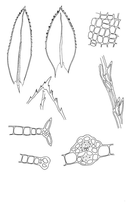
| Mnium thomsonii W. P. Schimper [Mniaceae] | ||
|---|---|---|
 |
||
| Literature | Crum and Anderson 1981; McGrew 1976. As Mnium orthorrhynchum Koch 1950a; Showers 1982; Spjut 1971. |
| Illustrations | Abramov and Volkova 1998; Crum and Anderson 1981; Flowers 1973; Ignatov and Ignatova 2003; Koponen 1972; Smith 1978. |
| Bioregions | CaR, CW, NW, SN, SNE. |
| Vouchers | El Dorado Co.: Silver Fork Campground along Silver Fork American River, Eldorado National Forest, Norris 82915; Fresno Co.: Grizzly Creek at junction with South Fork Kings River along Highway 180, Sequoia National Forest, Shevock 12445; Lake Co.: Alder Creek, Cobb Mountain, Toren & Dearing 7089 (CAS) [determined by Wyatt]; Marin Co.: trail near Mud Lake, Point Reyes National Seashore, Norris 71833; Mono Co.: Lundy Lakes Trail along Mill Creek, Toiyabe National Forest, Norris 78903; Tuolumne Co.: Mill Creek below Cascade Creek Campground, Stanislaus National Forest, Norris 78823. |
| Copyright © 2024 Regents of the University of California
We encourage links to these pages, but the content may not be downloaded for reposting, repackaging, redistributing, or sale in any form, without written permission from The University and Jepson Herbaria. |